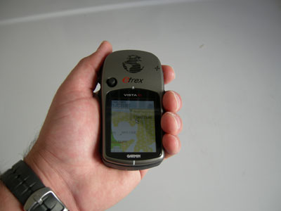
Garmin eTrex Vista C GPS
A GPS is a great piece of equipment to take on paddling trips. It tracks distance and speed so that accurate planning is possible and it can also help with planning and safety. By seeing exactly where you are, the GPS and maps can help with navigation. Many GPS units available have built in maps making them considerably more useful.
Handheld GPS units do have limitations. They require batteries to run, so always carry a spare set where they will stay dry and be easy to reach. The Garmin eTrex Vista C is the GPS unit I carry on each paddling trip. Garmin claims that this unit is waterproof, but I always carry it in a waterproof plastic carrying bag and attach it either to my spray skirt or deck. I do not know if the unit floats, but inside the carrying bag, there is enough air to make sure that it does not sink.

I also purchased the MapSource United States TOPO to augment the maps supplied with the eTrex Vista C. Adding these maps improves the detail of coastal regions. Using the software provided, parts of this three CD set can be loaded into the GPS. The memory of the eTrex is large enough to hold the maps for most of the Chesapeake Bay. The software that came with my version is only Windows compatible.
Using a GPS on a paddling trip is a great tool, but it does not replace having knowledge of your current location and hardcopies of maps. The eTrex Vista C comes with a built in compass. After it has been turned on and set, the eTrex can point north even while rotating in place. Older GPS units point north by determining the change in position. This works quite well in moving cars, but leads to problems in slow moving or stationary applications. It is a good idea to carry a compass as a backup to the GPS. With a hardcopy of the maps, a compass, and navigation skills, you can get back to the launch site even if you have trouble with a handheld GPS.