Paddling Triadelphia Reservoir
Update for 2016
Links updated in 2011 section.
The cost for a day use permit is $6, and a yearly permit runs $70. These permits can be purchased at the Brighton Dam Visitors Information Center (see below). Fortunately, there is an app the that allows purchase without making a trip to the Visitors Center.
Another great update from the WSSC is the new map of the reservoir. Maps were available at the Visitors Center, but now they are available online. Here is a link to the WSSC map of the Triadelphia Reservoir.
Update for 2011
I have just picked up my water use permit from the Washington Suburban Sanitary Commission (WSSC), but my paddling season has had a slow start. With both cold air and cold water, the risks of hypothermia require additional precautions. Finally, in the end of May, I have taken my kayak on the Triadelphia Reservoir to start the 2011 season. I have confirmed that many of the smaller boat launches on both Reservoirs will be available to boat traffic this season. For Triadelphia Reservoir, both the Big Branch and the Pig Tail Area have been reopened to boat traffic. Currently, these appear to be available as the WSSC map describes. To confirm this information, the WSSC Visitors Center can be contacted at 301-774-9124 or this data can be confirmed when you pick up your water use pass.
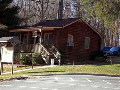
Before you can go to the launch site, you need to pick up a permit from the Washington Suburban Sanitary Commission (WSSC) that manages the Triadelphia Reservoir. At the time of this writing, permits could be purchased from 7:00AM to 4:30PM weekdays and weekends. A day pass costs $5 and a season pass runs $60. Full details are available on the WSSC web site. The Brighton Dam Visitors Information Center where these passes can be purchased (shown in the picture) is located at GPS coordinates (N 39° 11.471' W 077° 0.424'). A map to this point can be found here.
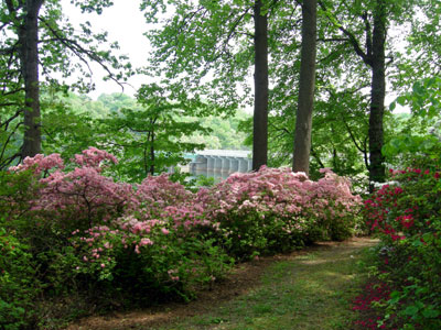
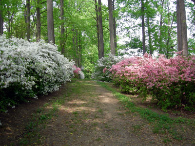
Across the street from the Visitors Center is the azalea garden. The azaleas are in full bloom in May and this makes for a nice walk. The trails through the garden are fairly short, so taking some extra time to walk through is definitely worthwhile.
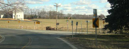
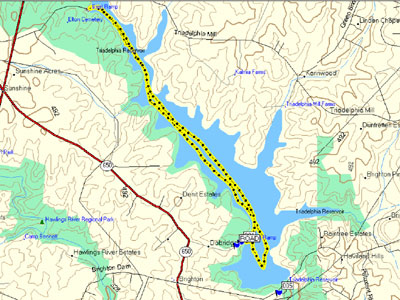
A great map of both the Triadelphia Reservoir and Rocky Gorge Reservoir is provided by the WSSC. To get to the launch site for the Triadelphia Reservoir, leave the parking lot and turn left. Make your first right on New Hampshire Avenue. From New Hampshire Avenue make your first right on Green Bridge Rd. This is an easy turn to miss since all the signs say turn left, so I have included a picture below.
Driving down the road to the launch site, you will pass a winery on the left hand side before reaching the parking lot and boat ramp. The GPS coordinates of the Greenbridge boat ramp are (N 39° 11.919' W 77° 0.861').
Update for 2007
After unloading my gear and getting ready to launch, I noticed
that the short section of dock had been repaired. This access
will make it easier for fishing boats to be launched from this
site. The dock appears fairly stable and a Mom and her young son
were sitting on the dock enjoying the afternoon. The launch area
is large enough that a kayak and fishing boat have no trouble
sharing the area.
 As I was getting ready to launch a fishing boat
was returning. They had caught a really large fish. They had
taken a digital camera with them, and they showed me a picture of
it. The fish was being held at approximately shoulder height and
the tail extended below the belt. I did not think there are such
large fish in the reservoir, but this one was slightly smaller
than this fisherman's personal best.
As I was getting ready to launch a fishing boat
was returning. They had caught a really large fish. They had
taken a digital camera with them, and they showed me a picture of
it. The fish was being held at approximately shoulder height and
the tail extended below the belt. I did not think there are such
large fish in the reservoir, but this one was slightly smaller
than this fisherman's personal best.
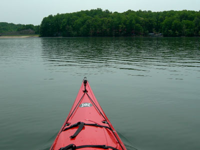
After pushing off from the ramp, I paddled to the right toward the dam. Hidden under the trees is the Triadelphia Azalea Garden. I swung around and headed northwest toward the main body of the reservoir. Since the water had been extremely low last season, many shrubs and underbrush had grown in the shallow sections. When the operation of the dam was resumed, all these plants were inundated and now only the woody pieces remain. I paddled my kayak through these regions looking for fish. Later my efforts were rewarded, and I saw a fish that was about a foot long. It was nothing like the picture I saw earlier, but it was a great find anyway.
I continued to paddle toward the northern most boat launch. This launch is called the Triadelphia and is located at the end of Triadelphia Lake Road in Montgomery County, Maryland. Along most of this section of the trip I saw no other boats or people and enjoyed the peaceful remoteness of the area. It is really amazing that a place like this exists between Baltimore and Washington. There were no sounds of traffic or mechanized sounds other than the occasional jet crossing overhead.
After about two miles, I started to see other kayaks and fishing boats. I knew that I was getting closer to the Triadelphia launch site. At the 3.75 mile mark, I reached the landing and got out for a short break. Since this was my first trip for 2007, I was really ready to get out stretch my legs. It was a great day for paddling and the gentle breeze kept the bugs away and made the air feel cool.
A pair of fishing boats was lining up to get out of the water, so I decided to end my break and clear off the boat ramp. The day was great, the water was cool, the sun was out, and I was paddling on the Triadelphia on a lazy afternoon. What more could I ask for with only a couple of hours to spend kayaking? The gentle breeze was bringing in some clouds and the bright sunshine was not as bright as on the way out. There was a chance of scattered showers later in the afternoon, but these clouds did not look like they would produce any rain. I made my way back with a gentle headwind. On the way back, I focused on my paddling technique. I made sure to extend the paddle forward, use my upper body to rotate through the stroke, and cleanly pull the paddle out of the water. By adjusting my stroke, I managed to go almost a mile per hour faster with less effort on the return trip. When I reached the Greenbridge launch site, I had covered a total of 6.9 miles in a little under two hours paddling time with a fifteen minute break at the Triadelphia launch site.
When I got home and put my gear away, I could feel the workout in my shoulders. It was a good trip to kickoff the 2007 season, and I look forward to many more great paddling trips this year.
Paddling Notes from 2006 and Earlier
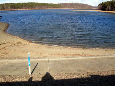
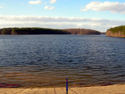
During most of 2006, the water level on the Triadelphia Reservoir was far below normal. The WSSC worked on the dam in 2006 and needed to access the lower sections of it to perform the work. As a result, the Reservoir was not open on the published schedule of March 1 through December 15. As of the beginning of July 2006, work on the Brighton Dam continued, and no completion date was available. As the two pictures below show, the water level in the Triadelphia Reservoir is now much higher than the Summer of 2006. The picture on the Left was taken on the seventh of January 2007. During my visit, I did not get an update on the schedule, but with the higher water level, we have a better chance in the 2007 season.
From the boat ramp, the Triadelphia Reservoir runs generally northwest with larger inlets running north. Near the dam there is a line of buoys that should not be approached in a kayak (or any other boat). This is a safety line and marks the region of the reservoir where current toward the dam can be significant. Opposite the boat ramp there is an inlet running east.
Since the reservoir does not allow gasoline-powered boats, the boat traffic is minimal. There often are several fishing boats, and they tend to be small craft with two or three people. Since they must be powered with batteries, the top speed is limited and the wake produced is smaller than the larger boats found on the Chesapeake Bay.
My last paddling trip on the Triadelphia was in the Spring of 2005. I generally traveled northwest and reached the second boat ramp. The minimum distance to the second boat ramp is approximately three and a quarter mile, but the amount of coastal exploring done can easily increase this distance. Beyond the second boat ramp, the reservoir continues another mile.